Mapping/GIS

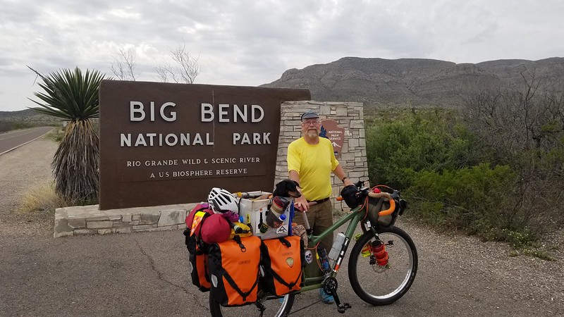
Had to throw GIS in the title – an acronym that always pricks up my ears 🙂 .  Friend S indicates in a comment that he’s following along & mapping my ride. I’m going to work on adding some sort of goog maps layer to make it easier for people, but until I get there I’ll try to make the underlying data ava to anyone interested in it. Looks like the best export source is Strava – my profile is here. I’ll try to download .gpx files for folks to a public goog drive folder here. And I’ll put links to both in the alt.tentacles section of the blogroll. Incidentally, alt.tentacles is where you’ll find links out to other thangs on the internet I populate and/or update.

P.S. Depending on the state of my goog drive filespace quota, the .gpx repository may be the X number of latest files – I think you can download any ancient history from Strava if necessary.

P.P.S. Nota benny: my World Wide Swim Club tumblog is listed in alt.tentacles. I’m documenting wild (and semi-wild) natation spots I’ve dunked in. If any other water fiends want into the Club, just let me know your Tumblr ID and I’ll share access (I ?think? I can do that).

Dawn at 7:49 - near the west side of the Central Time zone. (sunup at 7:54) #SandSAS

Bees, hills and a late night.

An eventful few days since Marathon. I’m pitched up at El Cosmico in Marfa after taking a tangent through Big Bend country. I’m going to take a couple days off – today is day 1 – to recharge after a few big mileage days. It’s not that I’m turning into a marathon hound, more that 60 – 70 miles seems to be typical distance between water sources out here in W Texas.

No deep thoughts to share. I’m a little embarrassed to admit that a lot of my thinking this leg has been of the “one more hill, John” and “jeez my ass is sore” variety. That’s part of bike hoboing too, it’s not all meditation on glyptodonts. One observation: it seems that I start to notice altitude somewhere around 3600 feet. Nothing super obvious – just not quite as much oomph in my legs and a bit of lightheadedness and the occasional flashbulb going off  when I stop to rest after a good climb. We’ll see how quickly I acclimate.

One last random observation – there are a lot of bike tourers here at El Cosmico, And I’ve met a few on the road. It’s likely a function of the time of year (not summer vacation), but I seem to be right in the middle of the demographic age-wise. I’m obv hors catégorie when it comes to co-pilot, unusual bike and general hobo attitude 🙂 .

20190321_135157

More…

Continue reading

Paris^H^H^H^H^HMarathon Texas

Taking a needed rest day in Marathon, Texas (a filming location for Wim Wender’s Paris, Texas – thus the title). It’s been a fun and strenuous few days moving out of scrub and caliche into high desert and mixed sandstone and caliche with real mountains on the horizon.

One of the things I’ve been thinking about while riding has been the past and the future of the land I’m riding through. I’ll save future for another day – too depressing – but imagining Pleisto-scenery has been a lot of fun. Two things have been big inspirations: all the vultures, black and turkey, eating road kill, and the rock shelters at Seminole Canyon. The vultures make me think of their big cousin, the California Condor and the tar pit illustration on the cover of Brooks’ Mythical Man Month. I’d really like to see something huge sitting on one of the roadside deer or calves. And another variety of road kill, armadillo, brings to mind an all time favorite: glyptodonts. The environment in and around Seminole Canyon reminded me a lot of the Dawn of Man sequence from 2001 – again tossing me back in time. So along I rode, imagining family groups of glyptodonts, herds of the extinct pronghorn, Tetrameryx shuleri, stalked by American cheetahs, all watched over by soaring condors. Proper!

Seminole Canyon

Travelogue below fold, as usual.

Continue reading